Showing posts with label Americas. Show all posts

Saturday, 3 July 2021

Charleston in South Carolina

                                                          Charleston Ravenel Bridge ©Solange Hando

On a long inlet of the Atlantic Ocean, Charleston leads to the meeting point of four waterways, including the rivers Ashley and Cooper (above) either side of the main peninsula.

Opened in 2005, then the longest bridge of its kind in the western world, the Ravenel links downtown Charleston to the large suburb of Mount Pleasant, best known for the Patriot's Point naval and maritime museum.


Elegant Houses along the Waterfront ©Solange Hando

The harbour front where the rivers meet is a stylish area lined with grand historic houses, some open to visitors during the annual Festival of Houses and Gardens. 

But come spring or summer, everyone can enjoy the lush oleander and Palmetto trees (the local emblem) along the waterfront promenade on the way to the old Battery and White Point, named after bleached oyster shells. 


                                                        Charleston  Old Town ©Solange Hando

Historic Charleston grew rich on the slave trade but only steps away from the glorious mansions, the old town has a charm all of its own with cobbled alleyways dozing under the trees.

 There are wrought iron gates and balconies, shutters and potted plants here and there.
Step back in time along Chalmers Street and around the old French Quarter.


                                                                   Marion Square ©Solange Hando

Once a parade ground, this is now a lovely open space, popular with students, and a lively spot for the Farmers Markets held every Saturday in summer. It's also a place for festivals, such as the Food and Wine showcasing the delicious fare of the surrounding Low Country.

Nearby are Regent Street, full of luxury goods, and the city historic market selling local craft, most sought after but not cheap, traditional sweetgrass baskets hand-woven by the Gullahs (descendants of the slaves).


                                                     Pretty Place and Cottage Garden ©Solange Hando

Stroll around downtown or if time is short, enjoy a scenic ride in a horse-drawn carriage and you will appreciate the different styles of architecture and gardens, large and small, with flowers and trees.

It's a lovely city with a few surprises and sometimes it almost feels like a village out in the country.


                                                             Colours Say it All ©Solange Hando

This is the popular Rainbow Row along the East Bay, loved for its pastel-coloured façades and trees offering a welcome shade in the heat of the day.

As you wander around, look out for poinsettia, kumquat, crepe myrtle, roses and palmetto. Listen to the bells chiming here and there for this is a 'holy city' bristling with lofty spires.


                                                   Pineapple Fountain in the Waterpark ©Solange Hando

This is another local icon as in days gone by, sailors would place a pineapple in their garden or hang it in the window to let everyone know they were back and friends were welcome to come and have a chat. It is still  a sign of hospitality.

See the pier just to the left where tall ships and others can take you down towards the ocean, past Fort Sumter where the Civil War started in 1861.  Beyond are the barrier islands (bridges) with sweeping sands, palms, dunes and the surfers' paradise on Folly Beach, the 'Edge of America.'


                                                   Sunset on the Ashley River ©Solange Hando


Saturday, 6 February 2021

Travel Photos? So much to Remember

India ©Solange Hando

This is Khardung La in Ladakh, which claims to be the highest road pass in the world. Set on an old trade route, it is the gateway to the Nubra Valley but closed in winter.
You need a special permit to drive up the steep meandering road with precipitous drops, especially dramatic on single lane sections. Not much traffic up there but the odd overloaded bus or local authorities who always have the right of way. 


Namibia ©Solange Hando

South of Namibia's capital, Windhoek, that was an easy stop but truly exciting as you step out on the southernmost latitude where you can see the sun directly overhead. It wasn't quite the summer solstice just yet but knowing that the Capricorn stretches 36788 kms around the earth was impressive.


Eswatini ©Solange Hando

This is in Eswatini, the former Swaziland, one of Africa's smallest countries, bordered by Mozambique and South Africa. This was the final day of the annual Reeds Festival where after renewing the royal enclosure, women from across the country perform for the king.
'They all dance for the king,' said my friend, 'then by the end of the day he will choose his next wife.'
'Would you like to join?'


                                                               Canada ©Solange Hando

This is the amazing Athabasca glacier spreading out from the Columbia, the largest icefield in the Rockies. You can drive up there from Jasper or Lake Louise then enjoy a dizzying skywalk above the gorge, followed by a ride on the giant Ice Explorer. Then you can walk a few steps on the glacier, listening to rumbling avalanches and creaking crevasses as snowy peaks tower above you, at over 3000 metres.


                                                                     Reunion Island ©Solange Hando

Set in the Indian Ocean, this is a French Island between Madagascar and Mauritius, just 63 by 45 kms but one of the most active hotspots on earth.
This was my first trip in a microlight, circling and dipping around craters, ravines and the mighty Furnace Peak which erupts several times a year.  I was terrified but I loved it. Awesome...


                                                                       Madagascar ©Solange Hando

Four hours from Antananarivo, the capital, this is Lemur Island, on the edge of the Andasibe National Park. It's a refuge for wounded or endangered lemurs, including the ring-tailed above who decided to perch on my head. Approach the grasslands in a canoe and they venture right to the edge, exploring any stranger with their soft padded feet. 


                                                                     Himalayas ©Solange Hando

I love the Himalayas and this is taken on the fabulous flight from Kathmandu to Paro in Bhutan, the closest international airport to the kingdom's capital, Thimphu.
See the pyramid summit of Everest, 8849 metres, at the back, rising above the Nuptse wall to the left and the Lothse Peak to the right.
If you ever fly this route, make sure you get a seat on the left-hand site on the way to Paro.


Saturday, 7 December 2019

Images of Peru, Cusco, Machu Picchu, Titicaca

Cusco, Main Square ©Solange Hando

At 3400 metres, the former Inca capital is a lovely place with a mix of ancient remains and Spanish colonial buildings. Mountains, flower beds, colonial balconies and arcades, it's all there, around the spacious square or along the steep narrow lanes of the old town.


Santa Domingo in Cusco ©Solange Hando

The church/and convent were built on the site of an Inca temple -to ensure it could never be used again- but remains of the original walls survived earthquakes and are still visible.
The Incas always kept their way and in the cathedral, the Last Supper image is not bread and wine,but Andean cheese and guinea pig (their favourite meat). 


Weaving ©Solange Hando

This lady got it right, beautiful work, so much colour and the best tourist spot around, with great views of Cusco and nearby mountains... Who could resist?


Arriving in Aguas Calientes ©Solange Hando

Cusco is the start of the Inca Trail to Machu Picchu, just 40 km or so but 4 challenging days across the Andes.
The alternative is train or road with stunning panoramas and a chance to visit several Inca sites along the way.


Machu Picchu ©Solange Hando

Unless you trek, access to Machu Picchu is from the lively little resort of Aguas Calientes where a shuttle bus takes you to the site, totally hidden in the mountains.
It simply takes your breath away but be sure to book your ticket well ahead of time for visitors' numbers are restricted.


Pachacutec ©Solange Hando

The 9th Inca Emperor holds pride of place on the square in Aguas Calientes.
One of the most important leaders, he started building Machu Picchu, the work of 50,000 labourers and crafstmen which lasted 50-70 years. 


Lake Titicaca, Uros Islands ©Solange Hando

Shared between Peru and Bolivia, Titicaca (the'puma rock') is the highest navigable lake in the world  and said to be the birth place of the Incas.
It is 190 km long, 80 across at its widest, fed by 25 rivers and dotted with islands.


Traditional Boat on Floating Island ©Solange Hando

Close to the shore but most amazing of all are the floating islands, built with reeds and reshaped  as need be by the indigenous Uros Indians. 
The water is usually calm and perfectly blue and sailing on one of these magnificent reed boats, home- made like islands and huts, is out of this world.


My Friends, the Uros Indians ©Solange Hando


Saturday, 23 September 2017

Canadian Rockies, Athabasca Glacier, Columbia Icefield

The Athabasca Glacier in the Canadian Rockies ©Solange Hando

Located in the Jasper National Park and part of the Columbia Icefield, this is one of the world's most accessible glaciers, a comfortable day trip from Jasper (105 km) but also feasible from Lake Louise or Banff (195 km).

Up there, at 2000 metres, it's likely to be cold and the weather can change in minutes from dazzling sunshine to the odd snow shower. Take warm clothes and suitable shoes.  


The Skywalk, Athabasca ©Solange Hando


The Athabasca is a popular attraction so if you plan to take part in the 'double adventure', available in season, book well in advance, especially if you want to request specific times.

 The Skywalk is a good start, taking you on a semi-circular glass walkway suspended, it seems, between heaven and earth. Below you is the vertiginous drop of the Sunwapta Valley where pine trees cling tenaciously to barren soil, and towering above you, snow-capped mountains reaching over 3000 metres.


 Ice and Snow, Columbia Icefield, Jasper National Park ©Solange Hando


Take time to relax in the visitors' centre, browse the exhibitions and enjoy the stunning views then head down to the glacier for an exciting ride on the ice to the very edge of no man's land.

The Athabasca is six km long and up to 300 metres deep but despite some seven metres of fresh snow annually, this 10,000 year old natural wonder recedes by an alarming five metres a year, as you will see in places from the accumulation of rubble and rocks.


Ice Explorer on the Athabasca ©Solange Hando


Like some sort of giant from a fiction film, the Ice Explorer takes you down a very steep slope then across the ice until you reach the out of bounds limit. Rocky peaks, snowy tops all around and ahead of you, the pristine ice field laced with hidden crevasses.

Sometimes you might hear a rumble in the distance and witness an avalanche tumbling down towards you. It may send shivers down your spine but on a guided tour, you are in good hands.


Standing on the Edge ©Solange Hando


Then before the Explorer turns round, you can step out and walk on the ice, long enough to take a few photos, touch the snow and feel the vibes as clouds pile on the horizon above the stillness of this vast natural world.


Saturday, 12 August 2017

Niagara Falls, Canada

First View of the Niagara Falls from Canadian Side ©Solange Hando


Here they are: the American Falls to the left and the thin Bridal Veil, with Luna island between them, and to the far right, beyond the long Goat Island, the (at times disputed) Canadian Horseshoe Fall. 

The Niagara Falls are neither the highest nor the most scenic -within sight of the road and tourist developments- but they are the most powerful in North America and claim the highest flow rate in the world with an average of four million cubic feet per minute.


The Horseshoe, Niagara ©Solange Hando


With its 2600 foot wide crescent, the Horseshoe is the most expansive of the three falls, boasting up to 90% of the water. There are vantage points behind the fall, accessed via elevators and tunnels and that is one way to feel the full force of the water tumbling over 160 feet.

It may be a good place too to reflect on the many daredevils who defied the falls, the first one a 63 year old school mistress who went over in a barrel or the Frenchman Blondin who walked across on a tightrope, carrying his boss, top hat and all, on his back.


Getting up Close to the Horseshoe ©Solange Hando


But most exciting is the boat trip to the base of the falls where you can fully appreciate the height as well as the power and thundering roar.

The Horneblower on the Canadian side and the Maid of the Mist on the American side constantly ply the turbulent waters  with a full load of excited passengers. Plastic ponchos are handed out, red or blue respectively but expect to get wet nevertheless. Be careful with cameras.


The Upper Niagara approaching the Falls ©Solange Hando


After the boat trip, you can stroll  along the cliff-edge promenade, part of the parkland created to beautify the scene and prevent further developments.

Draining  Lake Eerie, the Niagara river flows north for 36 miles to empty its waters in Lake Ontario. Some 12,000 years ago, the falls were located near Queenston but due to erosion, they gradually receded south towards Lake Eerie.


Looking Downstream ©Solange Hando


Canada to the left, USA to the right and in the distance the Rainbow Bridge which forms the border. Nowadays walking across the bridge is subject to strict control and not as straightforward as it used to be.

Downstream, beyond the falls, the Niagara enters a gorge, over six miles long. It is too dangerous for kayaking but there is a rambling trail and an exciting aerocar to take you across the river, suspended in mid-air over a whirlpool. Nearby is the helicopter base for bird's eye views of the falls but if this is beyond budget, go up the Skylon Tower at the Falls and enjoy the panorama from the observation deck.


Aerocar downstream from Niagara Falls ©Solange Hando


Saturday, 29 July 2017

Toronto, Capital of Ontario

Welcome to Toronto ©Solange Hando

With a population 4½ times larger than Ottawa's, Ontario's capital almost feels like a dream, a true cosmopolitan city where all 'new Canadians' are welcome, regardless of origin, religion or culture.

It's Canada at its best, open, tolerant and caring under the guidance of its young liberal PM Justin Trudeau. The New Toronto City Hall (above) reflects success.


CN Tower and Harbourfront ©Solange Hando

Rising to 553 metres above lake Ontario, the communication tower has been the city's icon for over 40 years. In less than a minute, elevators whizz you up to the main observation deck (346 metres)  with a glass floor section, outdoor terrace and indoor refreshments.

If you really love heights, take the next lift and enjoy an even more dizzying panorama from 447 metres above the city and the white dome of the Roger's stadium. In season, adrenaline seekers can try the 'hanging over the edge' experience.


Toronto Islands on Lake Ontario ©Solange Hando


The CN tower also guarantees one of the best bird eye's views of the Toronto islands, 15 altogether interconnected by bridges or pathways across 5 km.

Just 13 minutes from downtown, it's a lovely escape from the bustling streets with nature trails and leisure activities, including boating and swimming. Spend a whole day if you can or book a tour from the harbourfront, worth it for views of the city's skyline on one side and the vast expanse of lake on the other.


Toronto from the CN Tower ©Solange Hando

On the north bank of Lake Ontario, Canada's largest city is hemmed in by ravines on the land side and an urban forest of 10 million trees. The economy is booming and developments are ongoing. 

This is a modern provincial capital with vibrant universities, thriving businesses and myriad tourist attractions from stunning museums and its world famous aquarium to vast shopping malls or the alleyways of China town and markets brimming with local produce.


Quaint and Stylish in Toronto ©Solange Hando


Wander around and you may well come across an old building or two tucked among the tower blocks or a quiet tree-lined district and brightly-coloured houses which seem to belong to another age.

Look out for Cabbage Town, originally an Irish working class settlement, now an attractive place with restored houses, or the Kensington area with colourful ethnic lanes and gentrified houses just steps away. Set on a grid pattern, the city is easy to explore, pick up a map and you can't get lost.


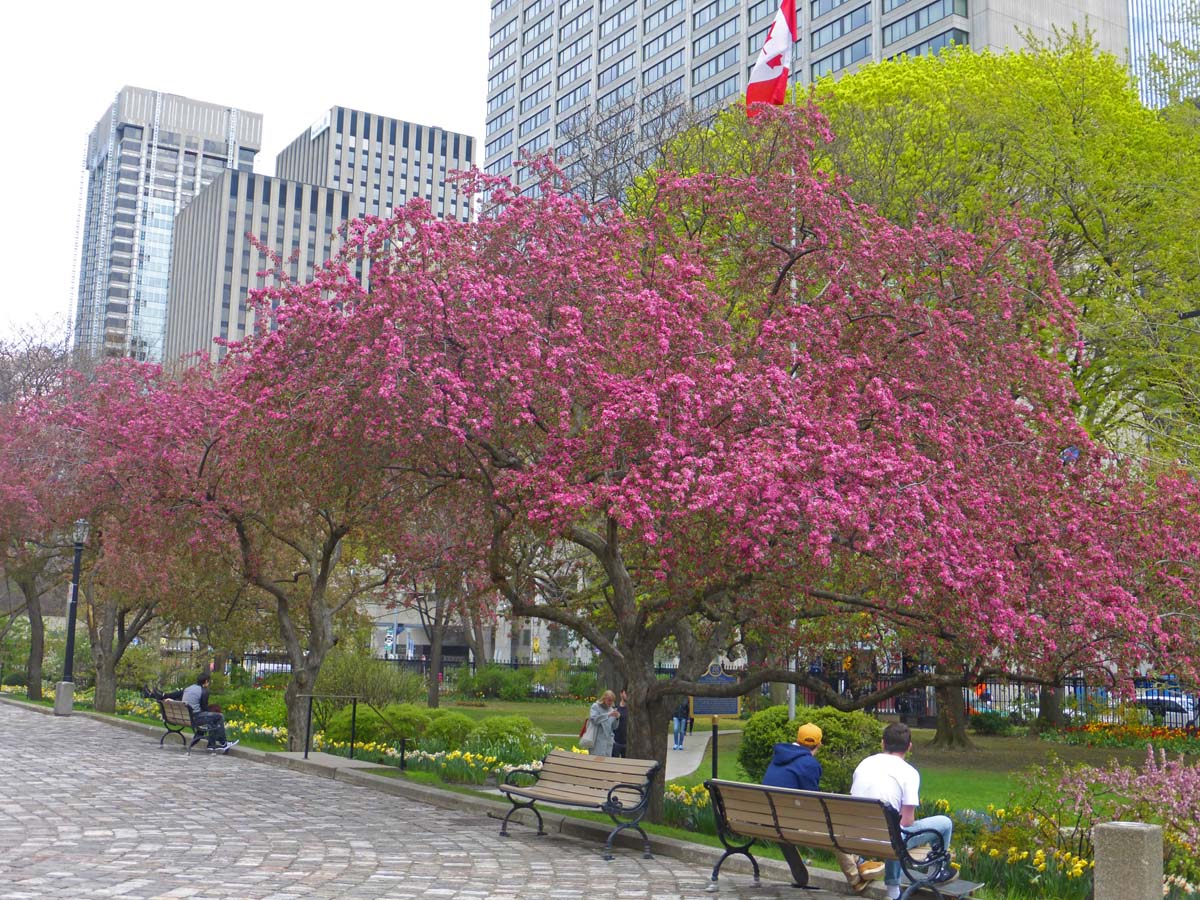
Cherry Blossom in Toronto ©Solange Hando

Toronto may have extremes of temperatures but it is nevertheless on the same latitude as the French Riviera and from spring blossom and tulips through to autumn, the many parks and gardens are simply delightful.


Saturday, 18 March 2017

Mexico San Cristobal de las Casas, Hotel Casavieja

San Cristobal de las Casas ©Solange Hando

In the highlands of Mexico south of the Yucatan peninsula, San Cristobal de las Casas is an attractive prosperous town with an impressive cathedral, stylish colonial buildings and quiet lanes, such as this one, where character hotels are tucked away behind traditional colourful façades.


Casavieja, Cool Arcade in Inner Courtyard ©Solange Hando

One would never guess what hides beyond the plain entrance of Casavieja, the 18th century building converted into a boutique hotel with rooms to suit a range of budgets. Character aside, the hotel top attraction is its central location in a quiet lane, just five minutes walk from the cathedral and downtown pedestrian area.


Standard Room in Casavieja ©Solange Hando

Guests can choose from 4 suites and 36 rooms furnished in colonial style with a few artefacts from the Chiapas region. Room size and facilities range from basic to luxurious according to price. 
Accommodation is on two levels around the inner courtyard. Heaters are provided in the rooms and free coffee is available in the lobby.


Quiet Corner in Casavieja ©Solange Hando

Brightened up with flowers and plants, reading areas and cosy corners are scattered around the building so guests can relax, meet friends and enjoy quiet times away from the hustle and bustle of downtown.
It's a little haven and even conference guests appreciate the peace.


Cool escape in the Courtyard, Casavieja ©Solange Hando

The courtyard is definitely a bonus filled with flowers and greenery, decorative features and convivial seating in the shade. Warm colours befit the traditional character of the hotel.
The Casavieja has a well-stocked wine cellar and two restaurants serving Spanish and Chiapas specialities.


Casavieja, Cristobal de las Casas, Mexico ©Solange Hando


Saturday, 4 March 2017

San Cristobal de las Casas, Chiapas, Mexico

San Cristobal de las Casas, Cathedral ©Solange Hando

In the central highlands of southern Mexico, this stunning cathedral in San Cristobal de las Casas draws locals and visitors alike from morning to night. With its warm colours and slender minaret-like turrets, it's the most striking legacy of colonial times in the ancient capital of the Chiapas state.


Weaving in Chiapas State ©Solange Hando

But alongside the Catholic faith, the indigenous culture is alive and well and the tourist market outside Santo Domingo's church is a great place to bargain for local craft. Chiapas is known for hand-made textiles -head for the villages to see weavers at work-, amber and jade but you will also find the usual assortment of tourist trinkets from hats and gloves to dolls or water bottles.


Southern Mexico Central Highlands ©Solange Hando

At 2,200 metres, Cristobal de las Casas nestles in a valley framed by pine-covered hills where streams,waterfalls and springs babble in fragrant greenery. Up in the mountains indigenous communities often live in isolation, following their own set of rules and even laws. 
Chiapas may be part of Mexico but as proved by its turbulent past and frequent unrest, the descendants of the Maya are their own boss and do not appreciate any kind of interference.


Market Day in San Juan Chamula ©Solange Hando

Up in the hills, roughly 10 km from San Critobal de las Casas,  the weekly market of San Juan Chamula attracts a fair number of visitors keen to enjoy the bright local colour and have a look in the unique temple-church. There, families who gather to pray sit around candles on a floor covered in pine needles; no pews or chairs, only indigenous gods and Catholic saints jostling side by side along the aisles.

As long as you are prepared to respect the rules, it is well worth a visit. No photos in the church or market except from one specific spot on the square. Don't try it on, you will be caught, shamed in public and unless your guide has untold patience and connections, you can say goodbye to your camera. Same applies to most of the of nearby villages.


Colonial Style, San Cristobal de las Casas ©Solange Hando

Back in town, the atmosphere is far more relaxed as you wander past elegant villas and cool arcades or head down the pedestrian street with its enticing restaurants and café-terrace, its food vendors and balloon sellers, giggling children and Maya women who do not shy away as long as you're prepared to bargain and buy.
On the town square, elders and weary-eyed tourists doze under the trees while the hypnotic notes of a traditional xylophone -played by three pairs of hands- drift in the evening air.


  San Cristobal de las Casas, Chiapas, Mexico ©Solange Hando

Meanwhile in the back lanes just minutes away, lovely character hotels hide among the colourful local dwellings which line the paved alleyways, heading straight as arrows towards the wooded highlands. 
Cristobal may be a city these days but it is still called 'the most magical village' and in the fresh mountain air, it truly feels like it.